"Takeshima in Illustrative Maps and Maps Vol.II " (絵図・地図からみる竹島(II))
2. The analysis of western made maps( 2. 西欧製地図の分析)
by Associate Professor Funasugi Rikinobu (Shimane University)
(舩杉力修 島根大学法文学部・歴史地理学)
(Overview)
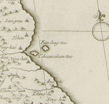
Western maps have been the object of the study in Takeshima-issue. According to Kawashima(1966), the map of Korea in "the collection of Chinese maps "by D'Anville (1779) have the two islands, "Tchiang-chan-tao"(west side) and " Fanling-tao"(East side) , the former being Usando the latter being Ullenungo in Chinese pronunciation, but these were just a copy of Korean old document. without investigation. This map had a great influence over European maps thereafter.
In 1787, when Dagelet found Ulleungdo, it was named after him, and the name "Dagelet" started to appear on the maps. In 1789 Argonaut found the Ulleungdo, named the island after it, but he failed to measure it exactly and spotted it on the map in the northwest of the real island; consequently , two islands for the one island, Ulleungdo, began to appear on the western maps.Arter that, Siebold compared the Japanese maps with European maps, and he mistakenly identified "Argonaut" with "Takeshima"(Ulleungdo) and "Dagelet" with "Matsuhima"(Takeshima/Dokdo);as a result, the map thereafter had been wrongly drawn under this misperception .
In 1849 French ship found Takeshima/Dokdo and named it Liancourt after its name, now the maps have three islands, "Argoaut"("takeshima"), "Daglet"("Matsuhima"), and Linocourt. But later it was found out that there was no island corresponding to "Argonot", so in 1900's the maps began to list only two islands, Daglet and Liancourt. The confusions were due to Siebold's misidentification. Korea claims that even western maps prove Dokdo was Korean territory just because D'ANVIL map has two islands, "Tchiang-chan-tao" and "Fanling-tao".
This paper will examine as many western maps as possible and investigate how these islands referred above appeared in the western maps. However, since the number of western maps is enormous and since it is difficult to systematically check them all, I took the following measures.
I have examined "the collection of classic maps of Japan" and "the compilation of old Japanese maps" among Akiyama Takeshiro's collection, and I also used the Internet western old maps on the website of Kansai University. In total, I examined 74 Japanese and Asian maps by European people which had Oki islands, Ulleungdo, and Taekshima/Dokdo. The times of the maps examined is from the middle of 16 century when Oki islands appeared for the first time in the western maps to the late 19 century when the boarder is not drawn as clearly as now. I summed up the result in figure 2 on another sheet.
① Until the middle of 18century
Only Oki islands were spotted on the western maps. That means westerns had no cognition of the western part of Japan Sea other than Oki islands. Oki islands appeared on almost all the western maps after the middle of 18 century. Some of the maps of Japan were made based on Japanese maps such as "map of Japan on a folding screen" (日本図屏風), which was probably made in the late 16 century in Joutoku temple of Fukui Prefecture(福井県), "South barbarian map on a folding screen(南蛮屏風), which belonged to the same family tree to the map just mentioned , "new anthology of maps about great Japan "(新撰大日本図鑑)(1678), "the map of Japan's mountains and sea(日本海山潮陸図)(1691)by Ishikawa Tomonobu (石川流宣). "Map of Japan on a folding screen" and "Southern Barbarian map on a folding screen" has Ulleungdo as Isotake between Oki and Goryeo but western maps based on them didn't list it for some reason. As a side, "new anthology of maps of great Japan" and "the map of Japan's mountains and sea does not have "Takeshima"(Ulleungdo) and "Matsuhima"(Takeshima/Dokdo) on them.

From the middle of 18 century, Tchiang-chan-tao(Usan) and Fanling-tao(Ulleungdo) began to appear on western maps. It might be that the map was made based on 1530 Korean map " "Map of the Eight Provinces (八道總圖 - 팔도총도)" in the middle of 16 century because the islands were spotted on the east of Korea and Usan is in the west, Ulleungdo in the east. As Kawakami points out, it seems these maps were under the influence of D'Anville.
D'Anville, Jean Baptiste Bourguignon(1697~1782) was a French geographer and published "new map of China" in 1737 (Left : from the site of Hokkaido University Library) based on the1735 map made by missionaries who stayed in China. Thereafter, this 1737 map had been the standard map of China, This map included the map of Korea, which had Tchiang-chan-tao、Fanling-tafor on it. (The national museum of Korea printed it in its leaflet.) Almost all the maps with these two islands locate Usan in the west, Ulleungdo in the east. "The map oft Japan" in 1750 located them similarly. It follows that Usan is not Takeshima/Dokdo.
Besides, this map is not a territorial map: it was just made based on "Map of the Eight Provinces" (1530) and Japanese maps of the middle of Edo era, so it had nothing to do with territorial boundary.
③ The early 19 century
In the early 19 century, maps with "Argonaut" and " Dagelet" came to existence besides the maps with "Tchiang-chan-tao" in the west and " Fanling-tao " in the east. These are all the name for Ulleungdo. In other words, four islands were drawn on the western maps in this period. "Argonaut" and "Dagelet" was "discovered " due to the developed technology of measurement at the time. "Dagelet" was discovered by French in 1787, "Argonaut" in 1789 by Britain. Since these islands were not colored on the map, they were recognized as no man's island. In this period, maps were made based both on traditional Korean maps and on western technology of measurements.
④From the middle of 19 century to the late 19 century
In the middle of 19 century, "Tchiang-chan-tao" and "Fanling-tao" gradually began to disappear from the maps. In some maps like the British map of "Japan and Korea" , 68th map on another sheet, only "Tchiang-chan-tao" disappeared and Fanling-tao、Argonaut、Dagelet remained. Incidenally, the maps were colored and Fanling-tao and Argonaut were colored yellow and Dagelet colorless, indicating tha Fanling-tao and Argonaut belongs to Korea and Dagelet belongs to no country. But since the maps were confused as to the existence and location of the islands, it has little significance. (By 1865 Argonaut finally disappeared from the map. * ) In 1840, Siebold mistakenly identified Argonaut with Takeshima and Dagelet with Matsuhima after he compared Japanese maps with western maps. Thereafter, however, his notation became a standard for western maps.
Takeshima/Dokdo notated as Linacourt began to appear on the western maps about this time. It was named after the French whaling ship Liancourt which discovered the island. (British map notated it as Hornet. I , though) Finally the maps began to depict Dagelet and Liancourt island accurately.
In the German map of Korean and Japan in 1870, (right / 72th map on another sheet), the present Ulleugdo was notated as Matsushima(Dagelet.) and in the south-east of it , you can see Liancourt.R(Hornet.I), Takeshima/Dokdo. Judging from longitude and latitude、they are accurately depicted. Interestingly note the boader line was drawn in the west of Matsuhima (Ulleungdo). The map showed the cognition that . the west of Ulleungdo was the boundary between Korea and Japan.
Incidentally Korean newspaper, Chosun Ilbo on 15 January 2004, reported that they discovered the French map in 1894 which indicated that Dokdo belongs to Korea. The map was in French daily newspaper Le Petit Journal in 1894 and the title was "the map of Korea, Japan, East China." They say that the map has the boundary between Korea and Japan, and Ulleungdo and Dokdo were on the map, Dokdo noted as I.Ouen-Sa (Usando).Translated by Ponta.
The Prof. of Hanyang University, Shin yon-ha said that it was the first time that the map with territorial boarderline was publicized and he concluded that Dokdo was internationally considered as Korean territory. However, examining the map closely, you'll find no Ulleungdo on the map which he claims to be drawn as Ulleungdo. Besides, I.Ouen-Sa(Usando), which he claims to be Dokdo, is Ulleungdo judging from longitude and latitude.:It is not Dokdo. And the present Takeshima/Doko is not depicted. This map is not the type based on the developed technology of measurement and belongs to the classic type of the map.
The wrong conclusion seems to be due to the error in the elementary method he employed: there is strong basis that Usando is Dokdo, the study is not based on the history of western maps and geography, even the longitude and latitude are not checked, which is very basic in reading maps.
In conclusion, western maps only recognized Oki Islans until 18 century. In the middle of the century Western maps were made based on 1530 Korean map "(八道総図), but since Usando was in the east, it follows that Takeshima/Dokdo was not recognized while Ulleungdo was during this period.
In the early 19 century, reflecting the advanced technology of measurement as well as traditional cognition of geography, there were several Ulleungdos on maps. In the middle of 19 century, finally some maps began to reflect the actual geography. In a nutshell, in western maps, Takeshima/Doko appeared only after the middle of 19 century after the advancement of measurement technology and before that, there was no map with Takeshima/Dokodo on it.
Hence, what was written as "Usando", as was the case with Korean maps, did not refer to the present Takeshima/Dokdo. In no western map was depicted Takeshima/Dokdo as Korean territory.
(* notes by translater : Japanese government seems not to have dropped Argonaut until 1878 when British Royale Navy dropped it from the chart in 1876 version)
(There is a list of the maps he studied in the original Japanese version.)
Courtesy of Web Takeshima Research Center.
"Takeshima in the Korean official map"
1530 - (1) 「八道総図」 in 『新増東国輿地勝覧』
1711 - (2)「欝陵島図形」
1770 - (3) 「欝陵島図 in'『朝鮮地図』
1882 - (4) 『鬱陵島外図』
1899 - (5) 『大韓全図』(1899) , 『大韓輿地図』(1900 c.a.
2007 - Supplement
"Takeshima in Japanese map (1)"
1849 - (1) 「嘉永新増 大日本国郡輿地全図」
References;
1752 - Fang-ling-tau means Ulleungdo
1894 - Carte De La Coree from "Le Petit Journal"
Hi Kaneganese, good job. And welcome back Ponta!
ReplyDeleteBTW, there seems to be some misspellings concerning Liancourt (spelelld as Linocourt) - although it's just a little thing.
Thanks.
pacifist
ReplyDeletePonta's translation was almost a year ago. I missed the chance to post it, but your post remind me his translation. I think yours was really good observation and actually prompt lots of consideration on the history of western maps, especially D'Anville's map, which is based on Chinese map. I wrote another post for the summery of matus and GROMR's comments. I'll post it after their check.
And thanks for the mistakes. I'll correct them right away.
Anyone doesn't know the detail description of those map?
ReplyDelete1.Year unknown...浄得寺日本図...A island west of Oki
2.Year unknow同世界図...Maybe Usando(West) and Ulleungdo on Korean peninsula part.