竹島問題の歴史

29.8.08

IHT: "A fierce Korean pride in a lonely group of islets"

The International Herald Tribune (IHT) has published an August 28 article on Dokdo by Choe Sang-Hun entitled "A fierce Korean pride in a lonely group of islets."
The IHT article comes out just one day after an Associated Press (AP) article by Kim Hyun-jin entitled "SKorean emotions run high over island dispute."
Is it just coincidence that two different articles written by two different men with Korean names have the same theme?
No, it is probably not a coincidence. Both of the men were probably part of the group of foreign journalists carried out to the islets this week on a South Korean Coast Guard ship as part of a government-sponsored tour, as was mentioned in the IHT article. However, I do not really understand why both articles seem to have the same theme, which is that Dokdo is more than just rocks to Koreans, and they will fight to keep them. Is that the message the Korean government wanted to send?
What was the message the Korean government was hoping to send by sponsoring this foreign press tour of Dokdo? Were they simply trying to tell the world, "We have control of the rocks and we are keeping them"?
Is it just coincidence that Korea's Chosun Ilbo posted an article today (August 29) entitled "Japan 'Should Recognize Korea's Effective Control of Dokdo,'" where it was reported that the "renowned Japanese economic and social critic Kenichi Omae" has urged the Japanese government to admit Korea's "effective control" of the Dokdo islets?
Is the Korean government now trying to take the attention off the history of Dokdo (Liancourt Rocks) and put it on "effective control"? If that is Korea's plan, then I think it is a good one because Korea's historical argument for the islets is so weak that to continue to focus on it would end up causing Korea a great deal of embarassment as the historical facts become known to the rest of the world.

28.8.08

AP: "SKorean emotions run high over island dispute"

The following is a link to an Associated Press (AP) article written by Hyung-jin Kim entitled, "SKorean emotions run high over island dispute."
One of the 40-member Korean police contingent stationed on Dokdo to guard the rocks had this to say:
"I always hated Japan and I've come to hate it more these days."
To me, that kind of hatred suggests a problem with Korea's education system, which is geared to fueling anti-Japanese feelings. Without realizing it, by feeding hatred, Koreans are hurting themselves more than they are hurting the Japanese.
Here is a Korean language summary of the article.

27.8.08

1903 Mar 30 - "Hwangseong Sinmun": "千山島에 二百二十名"

Below is a March 30, 1903 article from the Korean newspaper "Hwangseong Sinmun" (皇城新聞). The article seems to be reporting on a Japanese newspaper article that talks about Japanese immigrants to Korea, but I need to study it more before I can be sure.

One interesting thing about the article is that it says that 220 people were living on Usando (千山島에 二百二十名) and about 1,000 people were living on "Jukdo" (竹島에 約 千名), which is pronounced as "Takeshima" in Japanese. However, it also seems to be saying something about Japanese on Ulleungdo (鬱陵島), so it is possible that the Takeshima in the article was not referring to Ulleungdo. It is also possible that there was another "Usando" because I think I also remember their being another Usando on the West Coast of Korea.

Anyway, I would like some help in translating this article, which is not very clear. There may even be a record of the Japanese article it referred to, which would probably have also been published in March 1903. This may be an important piece of evidence, so I hope people will help me understand it. The article can also be found HERE.

Click twice to enlarge


26.8.08

1907 - "Chodeung Daehan Jiji" (初等大韓地誌)


The book pictured on the left was a Korean geography book entitled, "Chodeung Daehan Jiji," (初等大韓地誌 - 초등대한지지), which translates as "Elementary Level Geography of the Korean Empire." It was written by An Jong-hwa (安鍾和) and Yu Geun (柳瑾) and published in November 1907 as an elementary school geography book. It is stored in the National Libarary of Korea.
The book has only forty-three pages that are divided into twenty-four chapters. The first chapter is entitled "Location & Boundaries" and gives the location of Korea in relation to its neighbors in East Asia. It then gives the north-south, east-west latitudes and longitudes of the farthermost points of Korea, and then lists the names of those points. Korea's easternmost point was described as the island of Ulleungdo in Uldo County of North Gyeongsang Province (慶尙北道 鬱島郡 鬱陵島 -경상북도 울도군 울릉도).
 
Korea claims that Liancourt Rocks were a part of Uldo County (鬱島郡 - 울도군) and were referred to as "Seokdo" (石島 - 석도), but they have no evidence to support their claim. Moveover, the longitude given for Korea's easternmost point in the above geography book excludes Liancourt Rocks from Korean territory. Also, it lists the island of Ulleungdo in Uldo County as being Korea's easternmost point. If Liancourt Rocks had really been a part of Uldo County, then they would have been listed it as Korea's easternmost point. The fact that they were not listed is more evidence against the Korean claim.
 
The geography book also mentioned the island of Ulleungdo in more detail in Chapter Twenty-two, which was entitled "Scenic Communities" (勝地 都會 - 승지 도회). The description gave the longitude of Ulleungdo as extending from 130 degrees 35 minutes to 130 degrees 45 minutes, but Ulleungdo, including its neighboring island of Jukdo (竹島 - 죽도), actually extends from approximately 130 degrees 47 minutes to 130 degrees 57 minutes. This suggests that the longitude given for Ulleungdo in this chapter was an older, less accurate measurement than the one in Chapter One, which described Ulleungdo's eastern boundary as being at 130 degrees 58 minutes. The description in Chapter 22 also mixed up the names for latitude and longitude.
 
Ulleungdo was also described in Chapter Twenty-two as having an island named "Usando" (于山島 - 우산도) to the southeast, but no distance was given. Liancourt Rocks is ninety-two kilometers to the southeast of Ulleungdo at a longitude of 131 degrees 52 minutes, which is way outside the boundary the book gave for both Ulleungdo and for Korea's easternmost point.
 
It is possible the Usando mentioned in the geography book was referring to Liancourt Rocks (Dokdo), but it is also possible that it was referring to Ulleungdo's neighboring island of Jukdo (竹島 - 죽도). Usando was the old Korean name for Jukdo, which is about about 2.2 kilometers off the east shore of Ulleungdo. Actually, by 1907, Koreans on Ulleungdo were supposedly referring to Liancourt Rocks as "Dokdo" (獨島 - 독도) or by the Japanese name of "Yangko-do," while the original location of Usando had already been forgotten. (See "Location of Usando Unknown in Early 1900s.")
 
The following is my English translation of the relevant passages from the 1907 geography book. It is followed by the Korean text.
Chapter 1: Location and Boundaries
 
The Korean Empire is located in the eastern part of Asia. Its neighbor to the southeast is Japan, and it borders Russian territory on the northeast. The west and north border Manchuria, and the southern border faces faces the sea. Its northern latitude stretches from 33 degrees 13 minutes to 43 degrees 2 minutes. Its eastern longitude stretches from 125 degrees 50 minutes to 130 degrees 58 minutes. The eastern point is Ulleungdo in Uldo County of North Gyeongsang Province, and the western point is at Cape Jangsan in Jangyeong County in Hwanghae Province. The the southern point is Port Moseul on the island of Jeju in South Jolla Province, and the northern point is Tomun River in North Hamgyeong Province. The area is 82,000 square ri.

Chapter 22: Scenic Communities

Uldo is the old Ulleungdo. Its northern latitude stretches from 130 degrees 45 minutes to 35 minutes. It’s eastern longitude stretches from 37 degrees 34 minutes to 31 minutes. Three peaks prop up the sky. Its area is about 504 square ri. It produces many medical herbs and much timber. Usando is southeast of here.
-----------------

第一課 : 位置와 境界

大韓帝國의 位置는 亞細亞洲의 東部에 在하니 其境界는 同南은 日本을 鄰하고 東北은 俄領과 接하고 西와 北은 滿洲를 界하고 南은 海를 臨하니 北緯三十三度十三分에 越하야 四十三度二分에 止하고 東經一百二十五度五十分에 越하야 百三十度 五十八分에 止하니 東은 慶尙北道 鬱島郡 鬱陵島이오 西는 黃海道長淵郡 長山串이오 南은 全羅南道 濟州島 毛瑟浦 [摹瑟浦]오 北은 咸鏡北道 土門江이니 面積이 八萬二千方里니라.

第二十二課 : 勝地 都會


鬱嶋는 古鬱陵島이니 北緯 一百三十度 四十五分으로 三十五分에 至하며 東經三十七度 三十四分으로 三十一分에 지하니 三峯이 撑空하야 地方이 約 五百四方里오 藥材와 森林이 多産하며 于山嶋는 其東南에 在하니라.
 

23.8.08

1907 June - "Sinpyeon Daehan Jiri" (新編 大韓地理)

The book pictured on the left is entitled "Sinpyeon Daehan Jiri" (新編 大韓地理 - 신편 대한지리), which translates as "New Edition - Geography of the Korean Empire." It was printed in June 1907 and used as a middle school geography book. The book is stored in the National Library of Korea.
The book has 176 pages, and the main text is divided into three sections: Physical Geography, Cultural Landscape, and Regional Information. The book was largely a translation of the Japanese book "Korea's New Geography" (韓國新地理), which was written by Tabuchi Tomohiko (田淵友彦) and published in September 1905. However, revisions were made in the Korean text, including the renaming of the "Sea of Japan" (日本海) to the "Chosun Sea" (朝鮮海).
Other revisions included updated provincial information. For example, the Japanese text simply described the geography of the Korean island of Ulleungdo (鬱陵島), but the Korean version added the fact that Ulleungdo was made a county in 1900 and renamed "Uldo County" (鬱島郡).
One interesting thing about the Korean text is that it seems to have used the Japanese description of Liancourt Rocks without making any revisions. It even used the Japanese name of "Yang-ko" Island ("양고"島) to refer to the rocks. Koreans claim that Liancourt Rocks were made a part of Uldo County in 1900 and were called "Seokdo" (石島 - 석도), but they have no evidence to support their claim. Instead, the evidence suggests that "Seokdo" was just a catchall word used to include all the neighboring rock islets (石島) around Ulleungdo, including five small islets mentioned in old Korean texts and frequently shown on old Korean maps of Ulleungdo.
The fact that the 1907 Korean geography book did not refer to Liancourt Rocks as "Seokdo," but instead used the Japanese name for the rocks is more evidence against the Korean claim. Moreover, the coordinates given for Uldo (鬱島 - 울도) excluded Liancourt Rocks.
The following is my English translation of the section in the Korean book describing Ulleungdo (鬱陵島 - 울릉도), which was referred to as Uldo (鬱島 - 울도) in the text. It is followed by the Korean text.

Uldo

Uldo is Ulleungdo, which is in the middle of the sea about 400 ri away from Pyeonghae County’s Weolsong-po. In the third year of Gwangmu (1900), Uldo County was established and a magistrate was assigned. Its northern latitude is from 130 degrees 45 minutes to 53 minutes. Its eastern longitude is from 37 degrees 34 minutes to 31 minutes [The names for "latitude" and "longitude" are reversed.] The area is about 504 square ri. A tall mountain stands out in the center of the island. Its height is 4,000 cheok. There are no harbors on the shoreline, so it is extremely difficult for ships to tie up.

Flat ground is scarce on the whole island, but layers of fallen leaves and dried grass have accumulated and decomposed into dark, fertile soil, making it possible to have an abundant harvest without fertilizing. The annual output of soybeans, which is the island’s main product, is as much as 400 to 500 seok. The wood products include oak, paulownia, pine, and sandalwood. Grapes are also produced. On the shores, there is good production of sedum, which is clearly big. In the autumn, there are many flocks of woodcocks that are used as supplemental food. The fat is dissolved and supplied as lamp oil.

The residents of the island total about 500 families. About 300 Japanese families come to live on the island temporarily, which has caused the government to issue a standing order for them all to vacate and return home. There is a spring on the island that gushes out water that tastes slightly sour, but the island residents call it mineral water. They drink it when they are sick and it seems to have a good effect. This is the source of carbonated water.

About 300 ri to the southeast of this island is an island commonly called “Yang-ko” Island. It has an area of about thirty ri. The shoreline is indented, so it is good for anchoring fishing boats, but there is still no firewood or drinking water available, so it is uninhabited. There are many sea lions and various sea products.

---------------

鬱島

鬱島는 平海郡 越松浦 四百餘里海中에 在한 鬱陵島니 光武三年에 鬱島郡을 設하고 守를 寘하니 北緯 百三十度 四十五分乃至 五十三分. 東徑三十七度 三十四分乃至 三十一分 間에 在하야. 面積이 五百四 方里許며 中央에 高山이 屹立하야 고 – 四千 尺이며 沿岸의 港灣이 無하야 船舶의 碇繫가 甚難하니라

全島에 平地가 稀少하나 其地質은 落葉枯草가 堆積腐化한 黑土를 成함으로 膏腴하야 肥料를 不施하야도 農物이 豊碩하야 主産物의 大豆는 每年産額이 四五百石에 至하며 林産에는 欅, 桐, 松, 白檀香等이 有하며 또 葡萄가 産出하며 沿海에 良好한 石菜의 産額이 亦 大하니라. 秋季에 山鷸類가 多하야 副食物을 作하며 脂肪은 溶解하야 燈油에 供給하나니라.

本島住民은 五百餘戶며 日本人 三百餘戶가 一時에 來住함으로 政府에서 退去하란 命令이 有하야 至今에 盡歸하니라 島中의 一泉이 湧出하야 其味가 微酸하나 島民이 藥水라 稱하야 疾病時에 藥餌로 服用하면 効驗이 著見하니 此는 炭酸水의 源流니라.

本島東南約三百里에 一島가 유하야 俗稱 “양고”島라 云하니 長이 三十餘里오 沿岸이 屈曲하야 漁船의 碇泊이 便宜하나 薪材及 飮料水를 아즉 不得함으로 居人이 無하며 海馬와 各種海産이 多하니라.

22.8.08

Steve Barber in Korean News

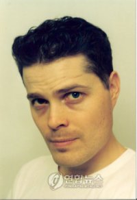
The Korean newspaper, "Joongang Ilbo," has posted HERE a picture of 44-year-old Canadian Steve Barber, who they say has lived in Korea for nine years and operates an English Web site on Dokdo (http://www.dokdo-takeshima.com/), which the article says provides a massive amount of evidence in support of Korea's claim on the islets.

Those of you who may not recognize the name "Steve Barber" may know him better as Toadface, Frogmouth, Wedgie, Zippertrout, or one of the other aliases he used to post under before getting caught. (See HERE.)

Steve had claimed that he had no affiliation with Koreans and did all the research on his own. Here is what he wrote back in 2006:

Kanganese, don’t lump me together with other Koreans on the Dokdo issue. I have done my studies on this subject on my own. My only connection with Koreans on this is for gathering maps and documents. Unlike Ponta and Pacifist I’m not an errand-boy for my local political organization such as Shimane Prefecture. I’m not Korean nor am I a part of a political movement like Ponta.
The following email was discovered on the anti-Japanese Web site "Killzap.cafe," a name that looks very similar to "Killjap.cafe":

From: steve barber [mailto:maemi30@hotmail.com]Sent: Thursday, August 31,
2006 1:01 AMTo: spar@paran.comSubject: RE:
Hanmaumy

From: steve barber [mailto:maemi30@hotmail.com]Sent: Thursday, August 31, 2006 1:01 AMTo: spar@paran.comSubject: RE: Hanmaumy

Dr Mr Cho:

I went onto Hanmaumy’s website and just by the visual images I saw I can say his website is the best I’ve ever seen !! I’m very impressed.

The problem is that it is all in Korean language. Koreans already believe Dokdo is Korean land so Hanmaumy is in a sense wasting his time. We must get this valuable information out to the global community. If the Dokdo issue ever goes to the ICJ it is absolutely necessary that all of the related information be available to the public in English.

Mr Cho I must stress these days there are more Japanese working with foreigners promoting Takeshima is Japanese and they are doing it in English while working with idiots like Gerry Bevers. Like after WW2 Korea isn’t getting its message out there about Dokdo.

That being said, Mr Lovmo’s site is up and running and I’ve been working on my own to try to gather information and translate it but to be honest my lack of ability in Korean language makes it impossible to gather images on some of these Korean National Archives Websites because they are totally in Korean.

We should use Mr Lovmo’s site because it is already quite popular and it has the greatest amount of exposure on the English/Foreign Internet.

Please me must work together to get the message out there. I will do my best. In addtion please tell Hanmaumy I am going to gather images from his website and translate as well as I can for Mark.

I would love to meet both of you someday.

Yours Truly:Steve

Korea's "Maeil Kyeongje" newspaper has also written an article about Steve Barber HERE, which says that Steve Barber's college major was computer studies, but that he came to teach English in Korea, where he became interested in the Dokdo issue two years ago.

It also says that his Korean is not very good, so his 34-year-old Korean wife has been translating into English the Japanese and Korean documents for him.

The article quoted Steve Barber as saying that his consistent position has been that Dokdo was Korean territory in the past, is Korean territory now, and must be Korean territory in the future. (Well, I guess he can no longer claim that he is a neutral party.)

Anyway, for someone who needs his Korean wife to translate the Japanese and Korean documents for him, Steve Barber seems pretty confident in his belief that Dokdo is historically Korean territory. Well, maybe if I were a 44-year-old man with a 34-year-old Korean wife, I might start supporting Korea's claim, as well.

Now that Yonhap has reported on Mark Lovmo, an elementary school teacher in Minnesota who needed a Korean friend to translate for him, and Steve Barber, an Canadian English teacher in Korea who needs his Korean wife to translate for him, I wonder who will be the next Korean-illiterate, Dokdo-loving foreigner that Yonhap News finds to interview?

Here are more Korean newspaper and news sites reporting the Steve Barber article:

How about a trade?

Pacifist or Kaneganese,

If one of you will translate and post on the Ulleungdo section of 田淵友彦's 1905 geography text 韓國新地理 for me, then I will translate the Korean version for you. The links to the relevant pages are "07" and "08" in the link I provided.

Is it a deal?

Gerry

21.8.08

"Projects Unveiled to Reinforce Sovereignty Over Dokdo"

An August 21 article in the Korean Times entitled, "Projects Unveiled to Reinforce Sovereignty Over Dokdo," talks about the Korean government's plans to reenforce Korea's sovereignty over Dokdo. The plans include the following:
  • Renovate a shelter for fishermen on Dokdo
  • Develop infrastruction on Ulleungdo
  • Begin joint projects to protect the enviroment around Dokdo
  • Promote international awareness of Japan's repeated claims over the islets
  • Rocks, breakwaters, and a museum dedicated to Ahn Yong-bok (who the Korea Times thinks defended Korea's ownership of Dokdo in in the 18th century instead of the 17th)
  • Strengthen education and promotional actitivities about Dokdo
  • Expand military drills and beef up the security of Dokdo by deploying more patrol ships near the islets

South Korea has a million-man North Korean army on its northern border, yet she seems to be more worried about an invasion of Dokdo.

20.8.08

1880 Map of Japan from Adolf Stieler's Hand Atlas 7th Edition

Here is a German map from the "Adolf Stieler's Hand Atlas (7th Edition)" which was printed and hand-coloured in Gotha in 1880 by Justus Perthes. The title of the map is "CHINA (OSTL.THEIL), KOREA UND JAPAN". In this map, "Matsu Sima (Dagelet I.)" and "Liancourt In. (d. Franzosen) / Hornet In. (d. Englander) " can be seen in the Japanisches Meer (Japanese Sea) with the National Border which indicates both of the islands above were Japanese territory.


Although Dagelet island (Ulleungdo) was actually not a Japanese island, Liancourt Rocks were drawn as Japanese territory again. This is another evidence that western countries believed that Liancourt Rocks belonged to Japan in the 19th century.
(Click the left map to enlarge)

Professor Claims Korea's National Institute of Korean History Mistranslated 1714 Passage

In his book, "History of Dokdo, Ulleungdo" (독도, 울릉도의 역사), Yeongnam University History Professor Kim Ho-dong (金皓東 - 김호동) claims that Korea's National Institute of Korean History (국사편찬위원회) has mistranslated a July 22, 1714 passage from King Sukjong's "Bogweoljeong-o" (補闕正吳 - 보궐정오).

The passage was a report from Jo Seok-myeong (趙錫命), who had been sent to Gangwon Province (江原道 - 강원도) to inspect the coastal defenses of the Yeongdong (嶺東 - 영도) region. In his report, he said that the people in the ports there told him that there was an island visible to the east of Ulleungdo that was on the Japanese border. The following is the relevant passage, Professor Kim Ho-dong's translation, and my English translation:

辛酉江原道御使趙錫命 論嶺東海防疎虞狀略曰 詳聞浦人言 平海蔚珍 距鬱陵島最近 船路無少礙 鬱陵之東 島嶼相望 接于倭境.

포인(浦人)의 말을 상세히 듣건대, '평해平海), 울진(蔚珍)은 울릉도(鬱陵島)와 거리가 가장 가까와서 뱃길에 조금도 장애가 없고, 울릉도 동쪽에 섬이 보이는데 왜경(倭境)에 접해 있다'고 하였습니다.

I listened carefully to the people in the ports (浦人) who said, "Pyeonghae (平海) and Uljin (蔚珍) are closest to Ulleungdo, and there are no obstructions along the sea route. Visible to the east of Ulleung is an island that is on the Japanese border."

Now, HERE is the translation of the passage by Korea's Korea's National Institute of Korean History (국사편찬위원회) and my English translation:

辛酉江原道御使趙錫命 論嶺東海防疎虞狀略曰 詳聞浦人言 平海蔚珍 距鬱陵島最近 船路無少礙 鬱陵之東 島嶼相望 接于倭境.

“포인(浦人)의 말을 상세히 듣건대, ‘평해(平海)·울진(蔚珍)은 울릉도(鬱陵島)와 거리가 가장 가까와서 뱃길에 조금도 장애(障礙)가 없고, 울릉도 동쪽에는 섬이 서로 잇달아 왜경(倭境)에 접해 있다.’고 하였습니다.

I listened carefully to the people in the ports (浦人) who said, "Pyeonghae (平海) and Uljin (蔚珍) are closest to Ulleungdo, and there are no obstructions along the sea route. East of Ulleungdo, islands connect to each other to reach the Japanese border.

In a footnote on the translation in his book (pp. 119 - 120) , Professor Kim Ho-dong wrote the following:

그런데 국편의 최근 번역에는 이것을 "포인(浦人)의 말을 상세히 듣건대, ‘평해(平海)·울진(蔚珍)은 울릉도(鬱陵島)와 거리가 가장 가까와서 뱃길에 조금도 장애(障礙)가 없고, 울릉도 동쪽에는 섬이 서로 잇달아 왜경(倭境)에 접해 있다.’고 하였습니다'라고 잘못 번역하고 있다.

However, the National Institute of Korean History has recently been mistranslating the passage as, "I listened carefully to the people in the ports (浦人) who said, "Pyeonghae (平海) and Uljin (蔚珍) are closest to Ulleungdo, and there are no obstructions along the sea route. East of Ulleungdo, islands connect to each other to reach the Japanese border."

Professor Kim does not offer an explanation for the mistranslation by Korea's National Institute of Korean History, but I think they mistranslated it because they realized the passage supported Japan's claim to Liancourt Rocks (Dokdo). The passage was essentially saying that the island visible to the east of Ulleungdo was Japanese territory. In those days, a country's farthermost islands represented its border. Apparently, the Korean fishermen had seen Japanese fishing boats coming from the direction of the island and assumed it was Japanese.

If the Koreans had believed the island to be Korean territory, then they would not have referred to it as being "on the Japanese border," but, instead, would have referred to it with an expression similar to "接于我國境" (우리 국경에 접해있다), which means "on our country's border."

If you look at the full passage, you can see that the Korean official was worried about Japanese territory being so close to Korea, which was why he was urging the government to strengthen defenses in the Gangwondo area.

Gangwon Provincial inspector Jo Seok-myeong (趙錫命) discussed the neglected coastal defenses in the Yeongdong region. Here is a summary:

I listened carefully to the people in the ports (浦人) who said, "Pyeonghae (平海) and Uljin (蔚珍) are closest to Ulleungdo, and there are no obstructions along the sea route. Visible to the east of Ulleung is an island that is on the Japanese border." In 1708 and 1712, strange-looking ships drifted to the borders of Goseong (高城) and Ganseong (杆城), so we know that Japanese ships frequently come and go. The government, however, says that the vast sea is a barrier, so there is no need to worry, but how can we be sure that a future war will not break out in the Yeongdong region instead of the Yeongnam region? We cannot allow even a little delay in taking measures to be thoroughly prepared.

In accordance with the request, the Myodang (廟堂) requested that Gangwondo be reprimanded to cracked down on its military officials.

19.8.08

Interview with Mark Lovmo about his Dokdo Site

The Korean newspaper, "Hankyoreh," has reported HERE on an email interview "Yonhap News" did with American Mark Lovmo about his Dokdo Web site HERE. The article is written in Korean.
"Segye Ilbo" also reported on the Yonhap article with a picture of Mark HERE.
<<<<------- Mark Lovmo
UPDATE: Now, even the Korea Times has an English article on Mark Lovmo and his Dokdo Web site entitled, "American Urges US to Recognize S. Korean Sovereignty Over Dokdo."
What's next? Mark Lovmo for President?

Same photo, different effects?

The photo below is of Dokdo (Liancourt Rocks), as seem from Ulleungdo. It was supposedly taken last November by a Mr. Kim Cheol-hwan (金哲煥 - 김철환) of the Maritime Policy Section at the North Gyeongsang Provincial Office from an altitude of 300 meters using a Nikon FM2 camera and a 200 mm lens. The second photo seems to be the same photo, but it is darker and more blurry. Why?

I am not sure which photo originally appeared in the Chosun Ilbo article HERE, but the second photo is the one that now appears in the article. The difference between the two photos has been discussed on the Internet, so it is possible that the photos have been changed. Both photos are stored in the Chosun.com image database.

Photo 1


Photo 2
Comparison of the Two Photos by Commenter GTOMR

"Dokdo is Korean Territory"?

Korean Dokdo propaganda videos are pretty much all the same. When it comes time to prove Korean claims, they just flash through a bunch of old Korean and Japanese maps and documents with little or no explanation, but with plenty of background music. The reason they do that is that they do not want people to look too closely at the evidence because then people might start asking such questions as, "Why do the old Japanese maps show Liancourt Rocks (Dokdo), but Korean maps do not?"

The Korean videos are designed to play on Korean emotions while relying on people's ignorance of the facts. That is why we see many Korean commenters here claim that Korea has a lot of evidence to support her claim on Dokdo, but then those same people are unable to explain what that evidence is.

Anyway, enjoy the video. At least, the music is nice.

18.8.08

1966 Japanese map from Junior High School Textbook

Today's news (August 18th 2008) reported about a Japanese map in 1966 which was from High School Textbook "新詳高等地図 最新版" (published on March 15th 1966). It was from the journalist's own textbook. Takeshima (Liancourt Rocks) was drawn as Japanese territory - it's natural because Japan has claimed so from the start. So the journalist wonders why Korea is claiming now when the guideline to teach Takeshima precisely was decided.

1951 June: New Zealand's view

History of San Francisco Peace Treaty: Extra (2)

Commentary on Draft Treaty by the Department of State on June 1, 1951


To follow is about New Zealand's view from the "Foreign Relations with the United States" (1951, Vol.VI pp. 1060-1061)


New Zealand


"In view of the need to ensure that none of the islands near Japan is left in disputed
sovereignty, the New Zealand Government favours the precise delimitation by
latitude and longitude of the territory to be retained by Japan as suggested in Article 1 of the United Kingdom's draft. The adoption of this device could for example make it clear that the Habomai Islands and Shikotan at present under Russian occupation will remain with Japan."


(Comment-In the discussions at Washington the British agreed to drop
this proposal when the U.S. pointed to the psychological disadvantages of seeming to fence Japan in by a continuous line around Japan
. The Japanese had objected
to the British proposal when it was discussed with them in Tokyo. U.S. willingness to
specify in the treaty that Korean territory included Quelpart, Port Hamilton and Dagelet also helped to persuade the British. As regards the Habomais and Shikotan, it has seemed more realistic, with the USSR in occupation of the islands, not specifically to stipulate their return to Japan.)


[Lots of thanks to opp]


17.8.08

1951 April - May: Joint UK and USA Draft

History of San Francisco Peace Treaty: Extra(1)

A Pro-Korean website comments as follows; The fatal flaw in Japan's interpretation of the San Francisco Peace Treaty is their misleading conclusion the agreement was between the U.S. Government and Japan. In reality, about 48 countries participated in the negotiations. Naturally other nations, such as the United Kingdom and commonwealth members, had views that weren't in line with U.S. policy” The website is trying to make their readers believe that UK and other nations were against the U.S. decision concerning the sovereignty of Liancourt Rocks.

But this commentary is not right. The draft which UK brought to USA indicated that Liancourt Rocks to be out of Japan’s territory indeed as earlier American drafts did, but the point the UK objected to the American draft was how to represent the territory of Japan, whether Liancourt Rocks were Japanese or Korean territory was not a problem. The UK draft that is shown below was providing the territory in the area within a line which was written using latitudes and longitudes in details.


To follow is the original UK draft, which was made on April 7th, 1951.


Part I. - Territorial Clauses


ARTICIE l

Japanese sovereignty shall continue over all the islands and adjacent islets and rocks lying within an area bounded by a line from latitude 30°N, in a north-westerly direction to approximately latitude 33°N. 128 ° E. then northward between the islands of
Quelpart, Fukue-Shima bearing north - easterly between Korea and the island of
Tsushima, continuing in this direction with the islands of Oki-Retto to the south-east and
Take Shima to the north-west curving with the coast of Honshu, then northerly skirting
Rebun Shima passing easterly through Soya Kaikyo approximately 142° E., then in
a south-easterly direction parallel to the coast of Hokkaido to 145° 30’ E.
entering Numero Kaikyo at approximately 44° 30’ N. in a south-westerly direction
to approximately 43° 45' N. and 145° 15' E., then in a south-easterly direction
to approximately 43° 35' N. 145 ' 35' E., then bearing north-easterly to
approximately 44° N., so excluding Kunashiri, and curving to the east and then
bearing south-westerly to include Shikotan at 147° 5' E., being the most
easterly point, then in a south-westerly direction with the coastlin6 towards
the Nanpo Group of Islands curving south to include Sofu-Gan (Lot's Wife) at 29°
50' N., veering to the north-west towards the coast of Honshu, then at
approximately 33° N. turning south-westerly past Shikoku to 30° N. to include
YakuShima and excluding Kuchino Shima and the Ryuku Islands south of latitude
30° North. The line above described is plotted on the map attached to the
present treaty (Annex I).(') In the case of a discrepancy between the map
attached to the textual description of the line, the latter shall prevail.


FROM:The National Archives of the United Kingdom FO371/92538,FJ1022/222


USA had a different opinion concerning how to express the territory. They preferred simple way. So representatives of the both countries had meetings on various dates including April 25th and 2nd May 1951 to produce the Joint U.S.-U.K. Draft which was made on May 3rd 1951.


Below is from the rercord of the U.S.U.K. Meeting on April 25, 1951:


SECRET
Anglo - American Meetings on Japanese Peace Treaty.

Summary Record of First Meeting held in Washington at 10.30 a.m. on the 25th April.


Present were:

United Kingdom

Mr. C.H. Johnston

Mr. G.G. Fitzmurice

Miss Dennehy

Mr. F.S. Tomlison

Mr. K.R.C. Pridham

United States

Mr. John M. Allison
Brig. Gen. Conrad Snow

Mr. Robert A. Fearly

Mr. Noel Hemmendinger

Mr. C. Arnold Fraleigh

Mr. Douglas Overton

[...]


CHAPTER II.


Mr. Allison said that the American View was that our defining of the Japanese boundaries would have a bad psychological effect on the Japanese and emphasize the contraction of their country. The Americans would prefer a wording which emphasized the full sovereignty of Japan such territory as we should leave her and, exclude by name from her sovereignty and only such territory and islands as might be necessary
to avoid confusion.


FROM:The National Archives of the United Kingdom FO371/92545, FJ1022/342


And below is the record of the U.S.U.K. Meeting on May 2, 1951:

SECRET

1076/357/510

Anglo - American Meetings on Japanese Peace Treaty.

Summary Record of Seventh Meeting held at 10.30 a.m. on the 2nd
May, in Washington


Present were:

United Kingdom

Mr. C.H. Johnston

Mr. G.G. Fitzmurice

Mr. F.A. Vallat

Mr. F.S. Tomlison

Mr. K.R.C. Pridham

United States

Mr. John M. Allison

Brig. Gen. Conrad Snow

Mr. Robert A. Fearly


[...]

UNITED STATES CHAPTER III


Both Delegations agreed that it would be preferable to specify
only the territory over which Japan was renouncing sovereignty. In
this connection, United States Article 3 would require the insertion of the
three islands Quelpart, Port Hamilton and Dagelet. It was left undecided whether
the sentence in British Article 2 requiring Japan to recognize whatever
settlement the United Nations might make in Korea should be maintained or not.
It was agreed that further consideration should be given to the drafting of the
sentence dealing with Japan’s renunciation of her mandates.

[...]


BRITISH EMBASSY,

WASHINGTON, D. C.

2nd May, 1951


FROM:The National Archives of the United Kingdom FO371/92547,FJ1022/376


They reached an agreement finally. They abandoned to express the territory in details using latitudes and longitudes, instead they adopted a simple expression as USA insisted – the islands which Japan should renounce were written as Quelpart, Port Hamilton and Dagelet. It omitted Liancourt Rocks. At this point, UK didn’t oppose the American thought – so one can say that UK admitted that Liancourt Rocks to be Japanese territory as USA decided.


Below is the record of the Joint U.S.-U.K. Draft made on May 3, 1951:

CHAPTER II

TERRITORY

Article 2


Japan renounces all rights, titles and claims to Korea (including Quelpart, Port Hamilton and Dagelet)', [Formosa and the Pesca-dores]; and also all rights, titles and claims in connection with the mandate system, [or based on any past activity of Japanese nationals in the Antarctic area]. Japan accepts the action of the United Nations Security Council of April 2, 1947, in relation to extending the trusteeship system to Pacific .Islands formerly under mandate to Japan. (U.K. reserves position on passages between square brackets.)


(Foreign Relations of the United States; 1951 Vol.VI p.p. 1024-1026)


16.8.08

1950 August: U.S. Draft of the Peace Treaty

History of San Francisco Peace Treaty: Part 6-C (Additional)
To follow is from the draft treaty which was made in August 1950.

[Thanks to けぺ]
CHAPTER II
SOVEREIGNTY
2. Subject to the provisions hereof and of any other relevant treaties, the Allied and Associated Powers accept the full sovereignty of the Japanese people, and their freely chosen representatives, over Japan and its territorial waters.

CHAPTER IV

TERRITORY


4. Japan recognizes the independence of Korea and will base its relation With Korea on the resolutions ,adopted by the United
Nations Assembly on December _, 1948


1950 July: Commentary on Draft Treaty by the Department of State

History of San Francisco Peace Treaty: Part 6-B (Additional)

To follow is the commentary on the draft treaty by the Department of State.
This is a firm proof that USA (the Department of State) admitted Liacnourt Rocks belong to Japan, not to Korea.
Details of the 6th draft will be available if you click the below:

Article 3


1. The territory of Japan shall comprise the four principal Japanese islands of Honshu, Kyushu, Shikoku and Hokkaido and all adjacent minor islands, including the islands in the Inland Sea (Seto Naikai) , Tsushima, Takeshima (Liancourt Rocks), Oki Retto, Sado, Okujiri, Rebun Riishiri and all other islands in the Japan Sea (Nippon Kai) within a line connecting the farther shores of Tsushima, Takeshima and Rebun; the Goto archipelago, the Ryukyu Islands north of 29°N. Latitude, and all other islands of the East China Sea east of Longitude 127°east of Greenwich and north of 29°N. Latitude; the Izu Islands southward to and including Sofu Gan (Lot’s Wife) and all other islands of the Philippine Sea nearer to the four principal islands than the islands named; and the Habomai group and Shikotan lying to the east and south of a line extending from a point in 43°35’ N. Latitude, 145° 30’ E. Longitude, and to the south of a line drawn due east on the parallel in 44°N. Latitude. All of the islands identified above, with a three-mile belt of territorial waters, shall belong to Japan.


“All of the islands mentioned above are shown on the map attached to the present Treaty.”


Paragraph 1.


Honshu, Kyushu, Shikoku and HokkaidoJapan was assured in the Potsdam
Declaration that it would be permitted to retain sovereignty of the four home
islands.


The Islands of the Inland Sea, Oki Retto, Sado, Okujiri, Rebun and Rishiri – These islands and lesser islands in the Japan Sea east of Tsushima, Takeshima and Rebun are almost exclusively populated by Japanese, have long been recognized as Japanese, were not “ taken by violence and greed”, and are closer to Japan than to any other nation. None has been claimed by another power and Japan’s right to retain them is not likely to be questioned in the treaty negotiation. In 1948 the population of Oki Retto was 44,000, of Sado 125,000, of Okujiri 7,000, of Rebun 9,000, and of Riishiri 20,000.

It laid emphasis on "not taken by violence and greed" and "none has been claimed by another power", these words are of course indicating that the author wrote the text keeping Liancourt Rocks in mind.


And the commentary illustrates Liancourt Rocks as follows:


Takeshima (Liancourt Rocks)
The two uninhabited islets of Takeshima, almost equidistant from
Japan and Korea in Japan Sea, were formally claimed by Japan in 1905, apparently without protest by Korea, and placed under the jurisdiction of the Oki Islands Branch Office of Shimane Prefecture. They are breeding ground for sea lions, and records show that for a long time Japanese fishermen migrated there during certain seasons. Unlike Dagelet Island a short not appear ever to have been claimed by Korea. The islands have been used by U.S. forces during the occupation as a bombing range and have possible value as a weather or radar station site.

It also mentioned that Liancourt Rcoks have never ever claimed by Korea.


(Many thanks to けぺ)