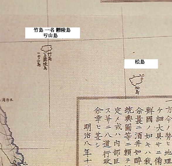
The above map is also a perfect example of how Japanese and Western maps often mismapped Takeshima and Matsushima in the 1800s . Though the Japanese believed Takeshima and its neighboring island of Usando to be Korean territory and Matsushima to be Japanese territory, the islands were often mismapped in the 1800s, due largely to a mapping error by the British ship "Argonaut" in 1789. The British ship mapped Ulleungdo (Argonaut) as being much farther northwest of its actual location and named it "Argonaut."
The shape and location of the island labeled as "Matsushima" (松島) on the above map tell us that it was actually Ulleungdo (鬱陵島), even though the island much farter to the northwest, was labeled as "Takeshima, also called Ulleungdo" (竹島 一名 鬱陵島). However, the island labeled as Takeshima (Ulleungdo) on the above map was actually the non-existent island of Argonaut.
Also, notice that the small island drawn just off the southwest shore of the island labeled as Takeshima was labed as "Ulsando" (亐山島), which was one of the misspellings of "Usando" (于山島). As I said above, this is evidence that the Japanese believed Usando to be a neighboring island of Ulleungdo rather than "Matsushima" (松島 - Liancourt Rocks), which the Japanese believed to be their island.
A Japanese survey of Ulleungdo in 1880 confirmed the mapping error.


Gerry, these maps show clearly a few things.
ReplyDeleteAt this point in time on Japanese maps showing 2 islands Takeshima to the West was not a “ghost island" but in reality Takeshima or Korea's Ulleungdo. First mapmakers of the 19th Century traced the earlier versions of Seibold's positional errors and located Takeshima (clearly Ulleungdo) and Matsushima (Dokdo) in more Westerly locations. So what the island "actually was" is irrelevant. What is important is the territorial perceptions of the Japanese at this time.
Japanese cartographers had long since known two islands existed in East Sea. One was Takeshima and the other was Matsushima.The map makers of this era had no clue about the shape and form of Matsushima and simply traced the islets drawn by predecessors Gerry. What is important is some maps of this era shows these islands as Korean land. (both of them)
DokdoKorean1
DokdoKorean2
DokdoKorean3
The Japanese had different opinions of Usando, some said it was "what Japanese call Matsushima" which would of course be today's Dokdo. The map you show does not show Usando as Matsushima Gerry.
UsandoMatsushima
Now whatever the positions these maps showed one thing can be said without a doubt. Japanese maps, consistently excluded both Takeshima and Matsushima from Japanese territory and sometimes showed the islands as part of Korea. This is despite the fact national maps of Japan included tiny remote islands such as the Ogasawaras and Pescadores Islands.
NoDokdoJapanMap1
NoDokdoJapanMap2
NoDokdoJapanMap3
NoDokdoJapanMap4
NoDokdoJapanMap5
NoDokdoJapanMap6
From this we know the Japanese had absolutely nothing to do with Ulleungdo or Dokdo before the Japanese Imperial Navy annexed the island for watchtower construction in 1905.
Anyone, is this maps assigned as "官許" or just a privator map?
ReplyDeleteSometimes I saw so many privator map which are not so much important with the decision of Japan govmement and those privator map is mostly listed on Korean's propaganda site.
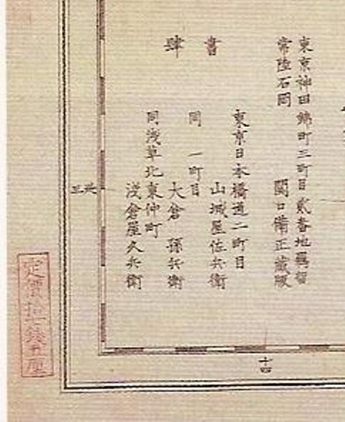
If possible please uplaod text part written in Japanese on right side?
Gerry,
ReplyDeleteI think the name of the map is Chosen Yochi Zenzu by Sekiguchi Mitsumasa.
GTOMR & Kaneganese,
ReplyDeleteI have added an enlargement of the writing in the left lower corner of the map. Could you confirm the mapmaker for me.
I'm not perfectly sure of Bishyo, Bisei, or Mitsumasa (備正),
ReplyDeletebut 輿地 should be read as "Yochi" definately.
Kaneganese,
ReplyDeleteYes, it should have been "Yochi." I mistyped it.
Steve Barber,
Just because the islands appeared on a Korean map does not make them Korean territory. The northeast corner of the Korean penisula stretches out into the Sea of Japan, so the islands are included in that span of sea. Also, notice that the islands are uncolored, just as Tsushima and the part of the Japanese mainland are unclored. Therefore, you cannot determine the ownership of the islands just by the fact they appear on the map.
What you can judge from the map, however, is that the mapmaker considered Usando as a neighboring island of Ulleungdo, not as Liancourt Rocks (Dokdo).
Anyway, I have to get to bed. Good night, everyone.
The map above is a perfect evidence the Takeshima(竹島) in
ReplyDeletethe position of Argonaut in the western maps is today's Ulleongdo and the Matsushima(松島) can't be Ulleongdo as pro-Japanese insist.
Though the shape and location of Matsushima(松島)is like those of real Ulleongdo due to the western mapping error, Matsushima(松島) indicates Dokdo.
The 1800s Japanese maps consistently depicted Matsushima(松島) as Korean land.