I investigated the 17 Japan-made maps of Korea and its surronding area which were made during the Meiji era since the last year of Edo period (1867) until the incorporation of the island in 1905.
Only four of the 17 maps included Liancourt rocks, including the map made in 1867 by Katsu Kaishu, a magistrate of navy in the Edo period. The four maps were made by Japanese navy or its affiliates, which explains those maps with Liancourt rocks were made for safe voyage. Other maps with the name of Chosun such as "Whole Chosun Map" didn't include Liancourt rocks, except the map (15) 朝鮮全岸 ("all coasts of Chosun") which also included Tsushima, Japanese territory. It was made for Japanese ships to make a safe voyage, not to clarify the territorial border. As a whole, one can say that Japan or the Meiji government didn't recognise Liancourt rocks to be Korean territory even before the incorporation of the island.
To follow is the list of the 17 maps.
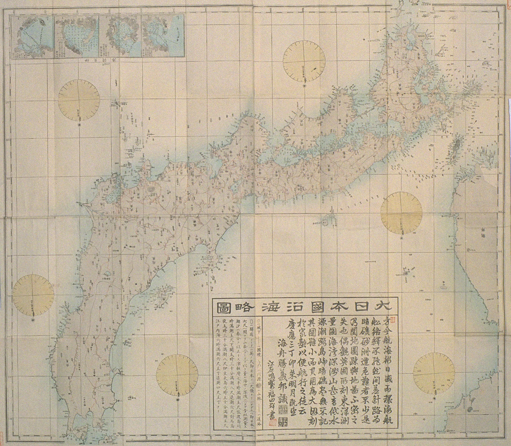
(1)大日本沿海略図 "Rough Map of Sea along the Coast of Great Japan" (Japan, Katsu Kaishu, 1867):Takeshima(lined with broken line)(=Argonaut), Matsushima(= Ulleungdo), リエンコヲルトロック Rienkoworutorokku(=Laincourt rocks)
http://www.lib.meiji.ac.jp/ashida/display/each/09/09-024-01/09-024-1-0.001.059-l.jpg
(2)朝鮮全図"Whole Chosun Map" (Japan, Waterway department of navy, 1873): 于山島 Usando - 蔚島Ulleungdo, (no Liancourt rocks)
http://www.occidentalism.org/?p=626
(3)朝鮮國細見全図 "Precise Map of Whole Chosun Country" (Japan, 丁子屋 1874):欝陵島(日本ニテハ是ヲ竹島ト云) Ulleungdo ("They call this Takeshima in Japan"), 于山島 Usando, (no Liancourt rocks)
http://www.occidentalism.org/?p=616
(4)亜細亜東部輿地図 "Map of East Asia" (Japan, Army staff bureau, 1875): Takeshima(=Argonaut), Matsushima (= Ulleungdo), (no Liancourt rocks)
http://www.tanaka-kunitaka.net/takeshima/asiaeast-1875/map.html
(5)朝鮮全図 "Whole Chosun map"(Japan, Army staff bureau, 1875): Takeshima(lined with broken line)(= Argonaut), Matsushima(= Ulleungdo), (no Liancourt rocks)
http://www.geocities.jp/tanaka_kunitaka/takeshima/chosenzenzu-1875/06.jpg
(6)朝鮮東海岸図"Map of East Coast of Chosun" (Japan,Waterway department of navy 1876): "Arugonafuta" island(lined with broken line)(= Argonaut), Matsushima(= Ulleungdo), オリオツ礁とメ子ライ礁 Oriotsu-sho & Menerai-sho (= Liancourt rocks)
http://www.geocities.jp/tanaka_kunitaka23/korea_eastcoast-1876/2.jpg
(7)朝鮮国全図 "Whole Map of Chosun Country" (Japan, Geography bureau,1882): Matsushima(= Ulleungdo), (no Liancourt rocks)
http://www.geocities.jp/tanaka_kunitaka/takeshima/chosenkokuzenzugeo-1882/ullungdo.jpg
(8)銅版朝鮮国全図 "Copperplate Print Whole Map of Chosun Country"(Japan, Kimura, 1882):Takeshima(Argonaut), Matsushima(= Ulleungdo), (no Liancourt rocks)
http://www.idokdo.or.kr/jpn/html/dataroom_text_map12.html
(9)日本本州九州及四国附朝鮮 "Japan Mainland Kyushu Shikoku with Chosun"(Japan, Navy 1891):Ulleungdo (Matsushima) ,リアンコールト岩 Riankoruto Iwa(=Liancourt rocks)
http://www.geocities.jp/tanaka_kunitaka38/honshukyushukorea-1891/takeshima.jpg
(10)明治二十七年六月朝鮮全図 "27th Year of Meiji, June, Whole Chosun Map"(Japan, Genzaburo Shibata, 1894): Ulleungdo, Usando, (no Liancourt rocks)
http://www.geocities.jp/tanaka_kunitaka/takeshima/m27-chosenzenzu/index1.html
(11)新選朝鮮国全図 "Newly Made Whole Map of Chosun Country"(Japan, 1894):Takeshima(= Argonaut)、Matsushima(=Ulleungdo), (no Liancourt rocks)
http://www.geocities.jp/tanaka_kunitaka/takeshima/senshin-1894/index1.html
(12)朝鮮輿地図"Map of Chosun" (Japan, Jotaro Shimizu, 1894): Takeshima (= Argonaut)、Matsushima (= Ulleungdo), (no Liancourt rocks)
http://www.geocities.jp/tanaka_kunitaka24/chosenyochizu-1894/5.jpg
(13)新撰朝鮮地理誌 "Newly Made Geographical Book of Chosun" (Japan, Saijiro Ohta, 1894):Takeshima (lined with broken line)(=Argonaut), Matsushima (= Ulleungdo), (no Liancourt rocks)
http://www.geocities.jp/tanaka_kunitaka/takeshima/chosenchirishi-1894/07ullungdo.jpg
(14)朝鮮全図 "Whole Chosun Map" (Japan, Tokyo Earth Science Association, 1894):Ulleungdo (Matsushima), (no Liancourt rocks)
http://www.geocities.jp/tanaka_kunitaka/takeshima/tokyo-1894/index1.html
(15)朝鮮全岸 "All Coasts of Chosun" (Japan, Waterway department of navy, 1896): Ulleungdo (Matsushima) , リアンコールド岩Riankorudo Iwa (= Liancourt rocks)
http://www.geocities.jp/tanaka_kunitaka31/koreacoast-1896/07.jpg
(16)亜細亜東部輿地図 "Map of East Part of Asia"(Japan, Rikitaro Kawai, 1898): Matsushima (Ulleung) (= Argonaut?)、Takeshima (=Ulleungdo?), (no Liancourt rocks)
http://www.geocities.jp/tanaka_kunitaka13/asiaeast-1898/03.jpg
(17)朝鮮全図 "Whole Chosun Map" (Japan, Bunjiro Koto, 1903): ULLEUNG-DO (MATSU-SHIMA), (no Liancourt rocks)
http://www.geocities.jp/tanaka_kunitaka6/koto-bunjiro/3.jpg
Gerry, the Japanese did not call Dokdo, Liancourt Rocks as a rule in the 19th Century. The islands continued to be called by both Liancourt Rocks and Matsushima by some long after some of Europeans called the islands as such.
ReplyDeleteThis page from the 1870 document show this to be true.
http://www.dokdo-takeshima.com/dokdo1870doc.html
anonymous,
ReplyDeleteYou seem to have been deceived by toadface's malicious technique.
The document in 1870 said that Takeshima-Matsushima are not related to Japan.
But the "Matsushima" in the document is not always Liancourt rocks. But toadface or the manager of the site intentionally place the map from 1833 (by Nagakubo Sekisui) just under the document to deceive people. In the Edo period like the map by nagakubo Sekisui, Matsushima was Liancourt rocks.
As you may notice that in those days the new Meiji government was in turmoil concerning the names of Takeshima & Matsushima. We will argue about this matter maybe in the near future in this site, but you can understand the turmoil if you look carefully at the maps we uploaded here. Argonaut became Takeshima, so the name of Matsuhsima went to Ulleungdo...
Anyway, Meiji government decided to investigate the area around Ulleungdo and investigated the area with the warship Amagi in 1880 and found the truth.
The map you indicated was the map in 1833 by Nagakubo Sekisui. Please take a look at the map section.
http://dokdo-or-takeshima.blogspot.com/2007/05/japanese-document-and-map-links.html
These maps from Edo period, before westernaization, is not accurate but remember that Japanese already knew the islands Takeshima (Ulleungdo) and Matsushima (Liancourt rocks), while Korean maps didn't depict the island.
It’s Pacifist who is trying to deceive the readers with western mapping error which has nothing to do with the Japanese document of 1870.
ReplyDelete"Matsushima" in the Japanese documents is not always Liancourt rocks, but "Matsushima" in the Japanese document of 1870 is definitely Liancourt rocks(Dokdo).
The 1870 document “How Takeshima and Matsushima became part of Chosun(Korea)…(竹島松島朝鮮附屬)” wrote as follows:
“…Matsushima is a neighboring island of Takeshima and we have no previous records of Matsushima....”
If Matsushima is not Dokdo, what else is Takeshima(Ulleongdo)’s neighboring island? Is it non-existent Argonaut? Absolutely not.
Pacifist admitted Matsushima was Liancourt Rocks(Dokdo) in the Edo period which ended in 1867. This document was written in 1870, 3 years later. In three years, Matsushima suddenly became Ulleongdo? No.
The western mapping error which the pro-Japanese people like to cite to cover the truth didn’t influcence the 1870 document. The Meiji Government didn’t officially call Ulleongdo Matsushima until Amagi’s survey in 1880. Even after Amagi’s survey, Japanese traditional name “Matsushima” for Dokdo amd “Takeshima” for Ulleongdo lasted until 1905.
Details on the 1870 document “How Takeshima and Matsushima became part of Chosun(Korea)” is here.
As for the map of 1833 by Nagakubo Sekisui, it’s clear evidence Japanese already knew the islands Takeshima (Ulleungdo) and Matsushima (Dokdo) and at the same time it’s clear evidence Japanese perceived Matsushima (Dokdo) as Korean land.
Nagakubo Sekisui’s map of 1833